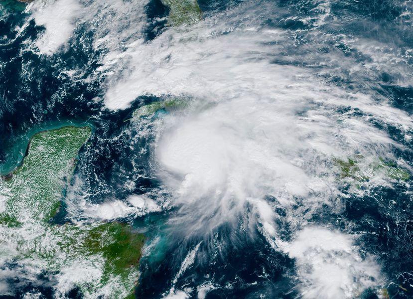
HAVANA (AP) — A strengthening Tropical Storm Eta sliced across Cuba Sunday and was aimed at the southern tip of Florida, where a hurricane warning was posted for a storm that has left dozens dead and over 100 missing in Central America, where it hit last week as a major hurricane.
The U.S. National Hurricane Center in Miami said the storm could become a hurricane before reaching the Florida Keys nd it declared hurricane and storm surge warnings for the Keys from Ocean Reef to the Dry Tortugas, including Florida Bay, with the storm expected to reach that area by Monday night or early Tuesday.
Eta had maximum sustained winds of 65 mph (100 kph) Sunday morning and it was centered just north of Cuba about 235 miles (380 kilometers) south-southeast of Miami. It was moving toward the north at 14 mph (22 kph).
In Florida, Gov. Ron DeSantis declared a state of emergency Saturday for eight counties at the end of the state as Eta approached, urging residents to stock up on supplies. South Florida started emptying ports and a small number of shelters opened in Miami and the Florida Keys for residents in mobile homes and low lying areas.
Miami-Dade County declared a state of emergency Friday night and also warned a flood watch would be in effect through Tuesday night.
Further south in the Keys, officials were monitoring the storm closely, but had no plans yet to evacuate tourists or residents. They urged residents to secure their boats and encouraged visitors to consider altering plans until Eta had passed.
Eta was once a Category 4 hurricane, and authorities from Panama to Mexico were still surveying the damages following days of torrential rains during the week.
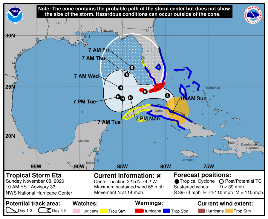
Tropical storm conditions are possible in the watch area in Cuba tonight and Sunday and in the watch area in Florida by late Sunday or early Monday.
A tornado or two may occur Sunday evening and Sunday night over South Florida and the Keys.
Significant, life-threatening flash and river flooding will be possible in Cuba, along with landslides in areas of higher terrain. Flash and urban flooding will also be possible for the Cayman Islands, Jamaica, the Bahamas, and South Florida.
A dangerous storm surge will raise water levels by as much as 2 to 4 feet above normal tide levels along the coast of Cuba near and to the east of where the center makes landfall. Near the coast, the surge will be accompanied by large and destructive waves.
In the U.S., the water could reach the following heights above ground somewhere in the indicated areas if the peak surge occurs at the time of high tide...
- Marco Island, FL to North Miami Beach, FL including Biscayne Bay...2-3 ft
- Florida Keys...2-3 ft
- Flagler/Volusia County Line, FL to Altamaha Sound, GA...2-3 ft
- North Miami Beach, FL to Flagler/Volusia County Line, FL...1-2 ft